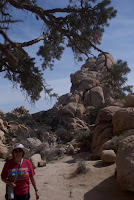
The last time I was in Joshua Tree, it was still a National Monument. I was here as a student in a basic rock climbing class which was part of a basic mountaineering course. Needless to say, that was quite a while ago. Seemingly, a lifetime ago. After stopping at the Cottonwood Visitors Center just north of the south entrance, we stopped for a short walk through a cholla forest. A somewhat frightening thought as the needles come loose very easily and are very painful to remove.
The demo I saw was tapping a cholla with the leather handle of a rock hammer and bunches of needles stuck to the handle. Anyway, as long as you didn't touch them, they look kind of cool. We are guessing that this is either some kind of fruit or flower on the ends. There weren't any explanatory leaflets in the box at the trailhead.
The next stop was Hidden Canyon. Apparently, this was a place for cattle thieves to hide their catch. A somewhat lush area surrounded by rocks. With easily defended approaches. The walk through the canyon was about a mile. There were a few rock climbers in small groups practicing their hobby. The class I took used Joshua Tree since the rocks gave you good grip and were pretty stable. They didn't flake off in your hand like some other locations. It's a good place to learn.
We then drove to Keys View which had a good view of the Coachella Valley. Mt. San Jacinto is the peak and I was hoping to be able to take the cable car from Palm Springs. But we learned that the road to the tram was one of those that was washed out during their recent flooding and won't be open again this year. To the right of the peak, you can see the smog/fog from the Los Angeles basin spilling out into the desert. It's almost like a wall. When I was learning how to fly, we came up to this wall and it was over 10k feet high, We had to come in under special VFR which meant relying on instruments following vectors from air traffic control. This was because you couldn't see the ground due to the density of the fog/smog layer.
The pano was the inside of Hidden Valley.


Bet many memories came to mind as you walked about.
ReplyDeleteA few. That was 40 years ago..And I didn’t see much beyond the rocks we were climbing and rappelling from. There was a orienteering challenge the next day but that was pretty straight forward. Map and compass as this was pre-gps.
DeleteThe pano is breathtaking. A wall a fog is just sad to think about. I can’t imagine living in a place where smog is so bad it appears as a wall to outsiders. Ugh.
ReplyDeleteThe mountains around the Los Angeles basin traps the smog. It isn’t anywhere near as bad as back in the mid-60s.
DeleteBeautiful photos and find memories! I can't wait to see Joshua Tree!
ReplyDeleteWere you planning on coming this far west on the current trip? When were you going to start in Colorado?
DeleteI really need to do an update post. We are heading to Colorado in mid-April, starting work in Estes in May, then OR, and CA for the winter. We have jobs lined up through Feb 2020. I'm hoping your question will motivate me to post a full update! 😊
ReplyDelete